By: 4R Plus
November 2018
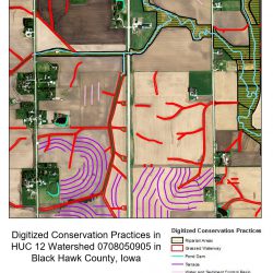
A statewide effort to identify and map six types of conservation practices demonstrates that Iowa has a proven track record changing the landscape for the better, says Iowa Department of Natural Resources Water Quality Bureau Coordinator, Adam Schnieders. He says the project paints a positive picture, as it reflects significant public and private investment in conservation practices established in the state.
The six practices in the mapping project include terraces, ponds, grassed waterways, water and sediment control basins, contour strip cropping and contour buffer strips/prairie strips. The value put on these practices equates to $6.2 billion in today’s dollars. “This tells a very good story on the amount of investment that has already occurred in the state,” said Schnieders, noting the project measured 88,874 miles of terraces, which is enough to circle the globe three-and-a-half times.
“Documenting the progress made by farmers demonstrates the collective value of the wide range of programs and individual efforts that have helped make these conservation achievements possible,” said Schnieders. “We need to build on this past success and continue to have everyone engaged to educate, fund, design, build and maintain conservation practices to achieve the goals set out by the Iowa Nutrient Reduction Strategy. This project shows we can change the landscape for the better.”
Iowa is the first state to analyze every watershed using LiDAR and aerial imagery to create a detailed assessment of conservation practices. The analysis is based on data taken from 2007 to 2010 and provides a benchmark for measuring progress.
Schnieders said additional efforts are underway to assess the status of these practices going back to the 1980s and also to assess the recent status of practices added from 2016 to 2018. Once complete, a robust timeline will help show the rate at which conservation practices have been added.
“One of the challenges in tracking progress of a major landscape initiative like the Iowa Nutrient Reduction Strategy is comparing change over longer time periods. Having a rate-of-change timeline will be helpful in telling the story,” he said. “With a baseline of the practices that are in place, along with the rate of change, we can better demonstrate progress and give people an idea of what to expect going forward.”
Additionally, the mapping data can be integrated with the Agriculture Conservation Planning Framework (ACPF), which is used by watershed coordinators to engage farmers and landowners in the planning process. “Now that watershed coordinators know where these six conservation practices are established, they can better locate where new conservation practices are needed,” Schnieders said.
4R Plus has developed a video to help farmers and other stakeholders understand the goals of the Iowa Nutrient Reduction Strategy. Click here to gain understanding of this initiative and the 4R Plus practices you can implement on your farm to help meet its goals.
It’s important to recognize the challenge we have in front of us in terms of nutrient reduction, he noted, but there are a lot of people and agencies that are willing and ready to help farmers adopt more practices.
“It’s going to take time to achieve the goals set out by the nutrient reduction strategy,” Schnieders said. “But if we can track progress along the way, we’ll show that we’re filling the buckets with practices that make a difference. This mapping effort proves that we can get a lot of practices on the ground over time. We just need to continue to be persistent like Iowans have demonstrated in the past.”